Clearing the air on the Australian Smoke Dispersion System

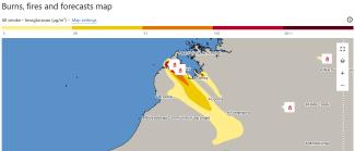
User interface with a zoomed in map of West Australian coast around Broome. It's titled 'Burns, fires and forecasts map'. Shows smoke levels from very high in dark red on the peninsula, spreading down to the southeast in bands of orange then yellow (lower smoke levels).
On this page

Clearing the air on the Australian Smoke Dispersion System

User interface with a zoomed in map of West Australian coast around Broome. It's titled 'Burns, fires and forecasts map'. Shows smoke levels from very high in dark red on the peninsula, spreading down to the southeast in bands of orange then yellow (lower smoke levels).
Written
  • Preparedness
  • Response
  • Bushfire

During the Black Summer bushfires of 2019–20, communities across New South Wales, Victoria and the Australian Capital Territory experienced prolonged exposure to thick smoke. In many places, smoke travelled beyond active fire zones, affecting cities, towns and regional communities. This created a unique challenge for recovery.

This experience was a reminder that smoke and poor air quality can have wide-reaching impacts. This is especially true for people with respiratory conditions and vulnerable communities already managing disaster recovery.

That’s why we have provided $2.319 million in funding to support the Bureau of Meteorology’s national smoke forecasting capability. With this support, the current smoke and air quality forecasting will expand from its existing coverage in Victoria and New South Wales to all states and territories.
Turning lessons into action

The Royal Commission into National Natural Disaster Arrangements was set up after Black Summer. It looked at disaster preparedness, emergency response, recovery efforts, and ways to better protect communities in the future. One of the recommendations from the Royal Commission highlighted the need for this smoke forecasting capability.

The Australian Smoke Dispersion System (ASDS) is a mapping and forecasting tool run by the Bureau of Meteorology. It predicts where smoke from bushfires and planned burns will travel at ground level, and how thick it will be. This will help fire agencies give clearer guidance for communities about impacts to air quality over time.

Expanding this system on a national level is a response to the increased complexity of natural hazards around the country. 

How the system works

The ASDS uses CSIRO’s AQFx smoke and air quality forecast model, together with fire spread modelling to determine smoke release, and burn location information sourced from satellite data and fire agencies. This provides a stronger national foundation for forecasting smoke from bushfires and planned burns, with specialised forecasting information made available to emergency services agencies to support planning, preparedness and operational decision-making

Improved smoke forecasting data can help inform fire and land management agencies about when and where to conduct planned burns. This aims to reduce community exposure to high smoke levels.

During bushfires, the capability can also support public information and warnings about hazardous smoke. This helps communities take practical steps to protect their health. 

How you can prepare

If smoke or severe weather is forecast, prepare ahead of time by downloading the Bureau of Meteorology (BOM) Weather app and turning on warnings so you can stay informed. Find your local ABC emergency broadcast frequency, write it down and keep it with your battery-operated radio, and program the station into your car radio. You can also download an air quality app to monitor local conditions and plan your movements when smoke levels are high.

Protect yourself from bushfire smoke by staying indoors with windows and doors closed, limiting outdoor activity, and avoiding strenuous exercise when air quality is poor. If you need to go outside, wear a properly fitted P2/N95 mask.

The delivery of this project on 31 August 2026 is another step in strengthening Australia’s disaster preparedness and resilience. It is investing in better information, stronger forecasting and national coordination. This is part of our goal to help reduce the impacts of future disasters and support safer communities across Australia.